VCM SOLUTIONS

Protect & Showcase Impact

Our Project Monitoring services give you the trusted, technical insights you need to manage risk and showcase the impact of your projects.

We use our audit-grade geospatial mapping, combined with our technical expertise, to produce comprehensive annual impact assessments of projects, supplemented with quarterly disturbance monitoring to identify issues before it’s too late.

Assess carbon impact with confidence

Get clear, credible results on the impact of your project with annualised updates using our independent, audit-grade nature mapping and carbon standards expertise. Our assessment is tailored to your project activity type and hosted on our web-based platform to enable you and stakeholders to engage with compelling geospatial analytics to showcase your impact.


FOR ARR arrow
We monitor changes in your project area and control plots to help you assess potential crediting discount prior to the end of your monitoring period. For more mature (3+ year) ARR projects, we provide robust carbon stock estimates using our LiDAR-based above-ground biomass mapping.
FOR REDD arrow
Our audit-grade land cover maps are updated annually across your project area to quantify key project performance metrics such as deforestation rates and leakage. We can also provide an independent assessment of credit integrity to help you assess over- and under-crediting of your project on an ex-post basis.
FOR IFM arrow
We support robust assessment of IFM project performance, helping to accurately quantify project performance against baseline, using our carbon stock maps combined with field data.
TANZANIA
PROJECT IMPACT
ANNUAL AVOIDED EMISSIONS
0 tCO2e/year

Add and review community and biodiversity benefits

Go beyond carbon. Store, visualise, and share community and biodiversity insights about projects you upload.


Measure ecosystem health arrow
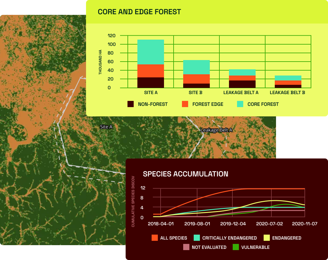
Review biodiversity indicators like forest connectivity and fragmentation, generated automatically by Space Intelligence.
Track species impact arrow
Add and analyse species lists, vulnerability status, and accumulation curves to show ecological outcomes alongside carbon metrics.
Show community insights arrow
Upload your own data on project revenue sharing, livelihoods, and social benefits to demonstrate the full impact of the project in one place.

Monitor loss risks in near real-time

Get insight into small-scale canopy loss in and around your project area before it’s too late to intervene. Our DisturbanceTracker technology gives you frequent insights into where and when degradation is happening.


Spot threats early arrow
Bi-weekly updates for potential degradation so you can act fast to prevent further loss.
Quantify loss with precision arrow
Verified, time-stamped reports on deforestation and degradation every quarter to quantify loss events.
Identify Losses in Challenging Ecological Conditions arrow
We use a combination of optical and synthetic aperture radar (SAR) to overcome typical geospatial challenges, such as cloud cover, that cause unreliable or intermittent results from other degradation tracking datasets.

Take a look around our Insights platform

Explore more of our data products & services

We provide a full suite of data products & services to support your entire project lifecycle, from screening all the way through to ongoing monitoring and auditing.

Contact us