Monitoring - Space Intelligence
VCM SOLUTIONS

Your project is always working.

Your monitoring should be too.

Continuous satellite-based monitoring solutions for NbS projects, offtakers, and financial investors. Assess risks, identify canopy loss, confirm growth performance, and protect your investment.

Nature-based carbon projects face continuous operational risks: from illegal encroachment, forest degradation, fire, to early planting failure. Traditional monitoring approaches such as field visits, optical data, or drone/UAV flights are expensive, infrequent and hard to scale across multiple sites. Threats to the project are only captured long after the window to act has closed.

Space Intelligence’s NbS Monitoring Suite delivers ongoing visibility into project risks, changes, and progress that allow you to intervene before issues escalate, make informed investment decisions, and demonstrate robust monitoring to stakeholders.

WHO IT’S BUILT FOR

Monitor early-stage ARR projects with GrowthTracker

The first years of an ARR project carry the highest risk of reversals but traditional remote sensing and other monitoring approaches fall short of tracking and alerting to project progress. GrowthTracker is the first commercial-grade remote sensing solution built to monitor early tree growth at scale and give actionable insights to protect projects.


Reliable Results. No Matter the Weather arrow
GrowthTracker uses Synthetic Aperture Radar (SAR) data that penetrates cloud cover to ensure consistent and reliable results across the year.
Verify Past Planting & Growth arrow
Confirm planting timelines and performance to date with independent, data-backed analysis – supporting due diligence and ongoing verification.
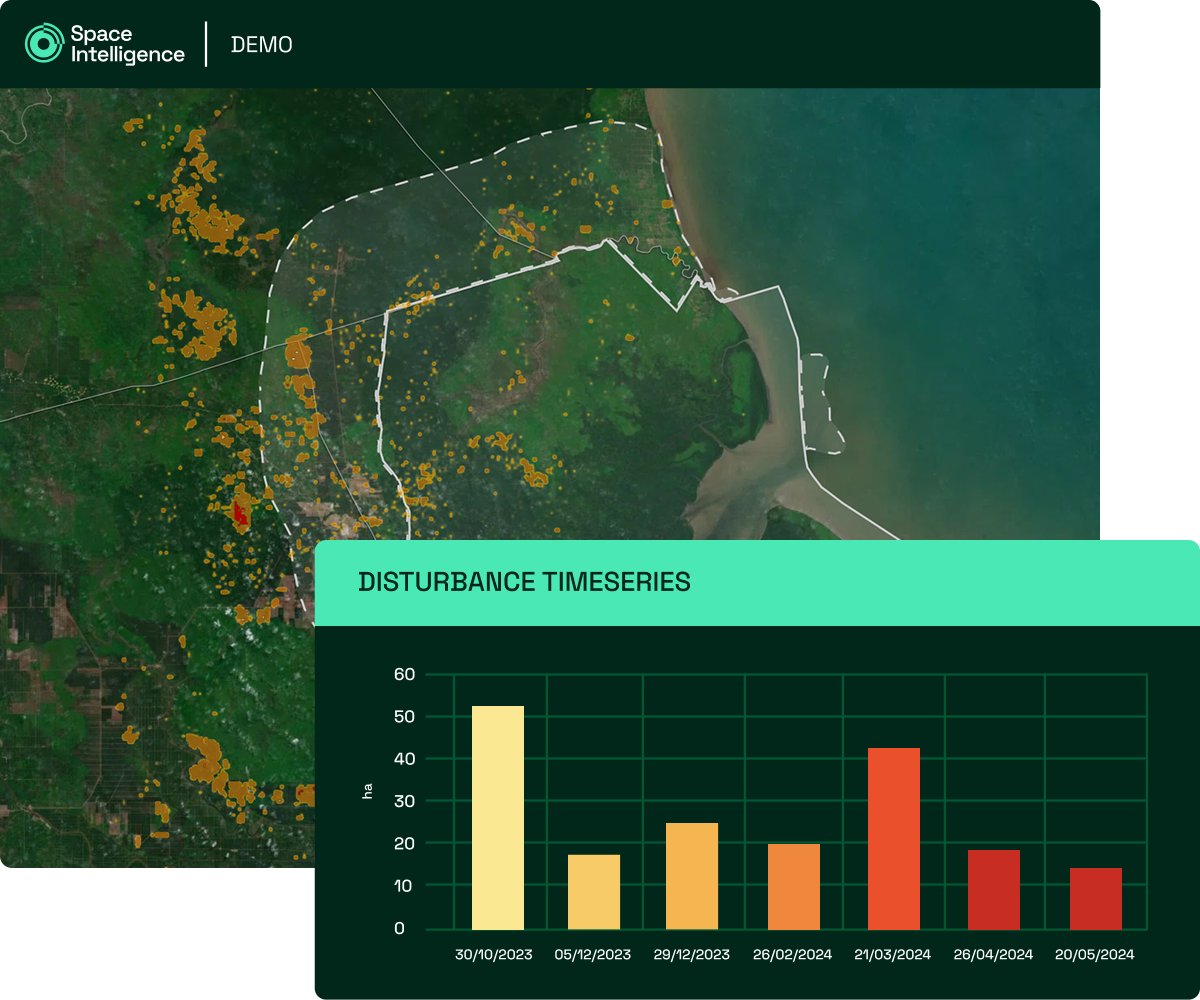
Be Alerted to Early Warning Signs arrow
Monthly status updates show project growth vs. expected trajectory, and provide early warnings on deviations that could indicate a loss and require intervention.

Assess and monitor permanence risks with FireTracker

Detect, assess, and respond to fire risk with full visibility – even through smoke and cloud. FireTracker maps the full extent of burn scars within and around your project area and assesses fire risk as far back as 2016.


Assess historic fire impact over 10 years arrow
Analyse over a decade of fire history to understand patterns, seasonality, and exposure.
See the full extent of fire. Not just live burns arrow
We map the total area burned during a fire event to provide a more accurate view of its full extent. Other models that use active fire tracking misses burns after the satellite has passed and underestimates the impact and risk.
Fire risk prediction arrow
Our data helps you identify high-risk periods and respond earlier with near real-time detection.

Monitor Leakage and In-Project Disturbances

Identify and respond to canopy loss before it escalates. DisturbanceTracker provides frequent, high-confidence insights into when and where canopy loss is occurring, in and around your project boundary.


Spot threats early arrow
Monthly updates for where and when degradation is happening so you can act fast to prevent further loss in project areas and leakage belts.
Quantify loss with precision arrow
Time-stamped, verified reports to bi-weekly periods help you measure, report, and act on loss events with confidence.
Ensure consistent and reliable results arrow
Combines optical and synthetic aperture radar (SAR) data to overcome cloud cover and other limitations that affect conventional monitoring.

Explore more of our data products & services

We provide a full suite of data products & services to support your entire project lifecycle, from screening all the way through to ongoing monitoring and auditing.

Contact us