5 questions to assess nature-mapping data quality
If you’re investing or buying credits, your net-zero claims are only as strong as the data backing them. If you’re developing a project, that same data influences how many credits you can issue – and how verifiable they are.
To build trust and confidence, forest carbon projects demand the use of data that can withstand audit – what we call “audit-grade” at Space Intelligence. Poorly calibrated nature data can throw off results, damage your credibility, and put your project’s financial future at risk.
So how can you tell if the geospatailly-derived dataset you’re relying on, whether for screening, monitoring, or verification, is truly audit-grade?
Start with these 5 questions. If you can confidently answer yes to all of them, you’re working with data you can trust.
1. Is it built for purpose?
Audit-grade data isn’t one-size-fits-all – it needs to align with the specific needs of your project. A dataset used for a pre-feasibility assessment will be different from one used for ongoing monitoring or EUDR compliance verification. Factors like map resolution, time span, and land cover classifications all come into play.
Many of these parameters are set by the carbon standard methodology you’re working with. For example, do the available time points align with the Historical Reference Period required by Verra VCS? Is the spatial resolution appropriate for what you’re measuring? Higher resolution isn’t always suitable for MRV due to processing efficiency, but can be preferable if you’re measuring very precise project boundaries in hard-to map-locations for EUDR compliance.
Geospatial satellite data must be tailored to your specific goals, whether that’s assessing project additionality, or evaluating feasibility before you invest.
2. Is it locally calibrated?
A forest in Kenya looks nothing like a forest in Scotland – and even less so across wet, dry or fall seasons, which is why your data needs to be calibrated to local and seasonal conditions.
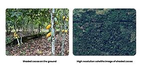
This is particularly important in complex landscapes. For example, in Vietnam and Côte d’Ivoire, coffee and cocoa plantations are typically grown under shade trees and planted with other species. In maps that use global algorithms and which aren’t calibrated for local context, these areas are frequently misclassified as forest due to high tree cover. This makes them ineligible for certain carbon projects, or could provide false positives for analysis of nature compliance such as EUDR.
That’s why our ecologists adjust each map to account for differences in climate, elevation, and vegetation types and make sure the data reflects real, measurable changes on the ground.
3. Is it aligned to the appropriate forest definition?
Then there’s the issue of defining a forest. The definition isn’t universal – take, for example, the EUDR forest definition:
“Land spanning more than 0.5 ha with trees higher than 5m and a canopy cover of more than 10%, or trees capable of reaching these thresholds in situ, excluding land predominantly used for agriculture or urban development.”
Now, compare that with Argentina’s national forest definition:
“20% canopy cover in a minimum mapping unit of 1 ha, with a minimum tree size of 3m.”
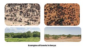
If you use the same forest definition across the entire globe, you might quite literally miss the forest for the trees. And we’ve seen it happen: uncalibrated datasets underestimated the true destruction of forests in Cambodia by about 20% due to their widespread conversion to tree plantations, which look like forests from bird-eye view.
That misclassification can lead to an inaccurate project baseline scenario – an estimation of what would have happened in the absence of the project. And since additionality is derived from comparing the baseline to project impact, a flawed baseline means you’re misjudging the project’s true impact. In this case, underestimating deforestation would mask the real value of the conservation effort and decrease the value of the carbon credit.
4. Does it cover multiple land cover classes?
Forests don’t exist in isolation. They interact with wetlands, grasslands, and agricultural zones, which is why a basic forest/non-forest classification often fails to capture the full picture. By analysing how different land cover types have changed over time, you can get a better understanding of the drivers of deforestation and identify risks to project success.
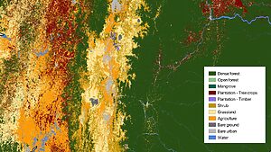
Additionally, applying class-specific allometric equations (biomass to carbon stock conversion) significantly improves the accuracy of carbon stock estimates.
This means the carbon stock maps based on multi-class land cover data present a clearer picture of how much carbon the project is actually removing from the atmosphere. Of course, better mapping doesn’t increase sequestration itself – but it does give you a more precise and credible estimate of the carbon being sequestered, which is important for additionality estimates and carbon credit integrity assessments.
5. Is it verified for accuracy?
It goes without saying that your nature data needs to accurately reflect what’s happening on the ground. No map is going to be 100% accurate, but some maps can approximate reality better than others.
At Space Intelligence, we take accuracy seriously. All of our maps go through rigorous post-processing analysis and the team goes to great lengths to manually verify map accuracy through independent point-based accuracy assessment. After the initial map drafts are created, where a satellite mosaic of the land is assembled and land cover classes are processed by our AI algorithms, our scientists select hundreds of statistically random points across the map and assess their accuracy “blind” using high-resolution imagery. We repeat the process for smaller project areas to achieve higher accuracy to match requirements of certain methodologies.
Conclusion
Not all nature mapping data is created equal.
If you want to be able to confidently defend your nature projects’ impact to stakeholders and the public (especially in the light of increased public skepticism of forest restoration and conservation projects), you need geospatial data that’s not just available, but also accurate, auditable, and representative of what’s happening on the ground.
So, make sure your nature-based project is built on a solid foundation: get in touch with our team and start with high integrity data.

