Comparing Forest Maps for EUDR Compliance in Brazil: Space Intelligence, JRC and MapBiomas
Testing whether a coffee or cocoa plantation is compliant with EUDR requires an answer to one question: was EUDR-defined forest within the farm boundary cleared after 31 December 2020? Getting a reliable answer heavily depends on the quality of the forest map you’re using.
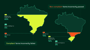
We tested the accuracy of Space Intelligence maps in correctly identifying compliant and non-compliant farms in Brazil, against two widely used open source datasets – MapBiomas Collection 10 and JRC GFC v2. Space Intelligence maps detected 100% of non-compliant coffee farms in Brazil while incorrectly flagging just 3% of compliant farms. By contrast, MapBiomas Collection 10 missed 65% of non-compliant farms, allowing them to pass when they shouldn’t. JRC GFC v2 performed better but still missed 1% and incorrectly failed 14% of compliant farms.
These results demonstrate why purpose-built EUDR compliance maps dramatically outperform open datasets for identifying deforestation on agricultural land.
About the datasets
- JRC GFC v2 is a dataset collated and funded by the European Union to ‘support’ EUDR compliance. It attempts to follow the EUDR forest definition, and to match the EUDR cutoff date of end 2020, at 10m x 10m pixel resolution, though with many constituent datasets at 30m x 30m resolution or coarser.
- MapBiomas is a high quality 30m x 30m pixel resolution annual landcover dataset produced by Brazilian scientists at INPE and other government bodies and research institutes. It is well known to be one of the best national landcover maps produced by a country, and is the basis of thousands of peer reviewed scientific papers. However, it was not designed to specifically meet EUDR definitions.
- Space Intelligence’s landcover dataset is built from raw optical and radar satellite data specifically for EUDR testing purposes, following EUDR’s definition of forest at 10m x 10m pixel resolution.
EUDR Forest Definition
Space Intelligence maps are specifically designed for use to test EUDR compliance for Brazil and therefore apply the official EUDR definition of forest:
Land spanning more than 0.5 ha with trees higher than 5 m and a canopy cover of more than 10%, or trees able to reach those thresholds in situ, excluding land that is predominantly under agricultural or urban use.
This definition creates a challenge for openly available global datasets. Coffee and cocoa are tree crops and farmland itself often includes shade trees, meaning that from satellite imagery, especially in historical data around 2020, productive farms can look indistinguishable from forest. Clearing shade trees or replanting crops may change tree cover, but it is not deforestation if the land was already in agricultural use at the cut-off date.
Any map that monitors tree cover rather than EUDR-aligned forest will misclassify these systems and risk failing compliant farms.
How We Tested
In an earlier assessment, we measured map accuracy using randomly distributed points across Brazil. That assessment covered 570 points and showed Space Intelligence forest/non-forest maps achieving an overall accuracy of 95%, compared to 92% for JRC Global Forest Change v2 and 91% for MapBiomas Collection 10.
However, most of those points were not in or near coffee or cocoa farms. The new assessment focuses explicitly on the hardest problem: testing compliance on real farms.
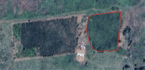
To do this, we focused on sun-grown coffee in Brazil. This is a comparatively simple and well-defined system, with large fields that can be identified with very high confidence using high-resolution satellite imagery, which eliminates the need for field visits.
We began by sampling random points within areas likely to contain compliant and non-compliant coffee, based on multiple datasets including Space Intelligence maps. When an expert analyst could see a point fell within a coffee field, we traced that boundary using recent high resolution satellite data to make a field boundary polygon.
Each field was then assessed by an expert to determine whether there was forest there on or after 31 December 2020. Those that were forest on or after that date are non-compliant with EUDR, as they were clearly deforested.
This process produced a dataset of 541 fields that could be confidently classified as either compliant or non-compliant.
Non-compliant farms were rare. Using this approach, and with high uncertainty as expected, we estimate that only a tiny portion of coffee in Brazil is non-compliant with EUDR – out of approximately 2 million hectares, only around 1300 hectares may be on land deforested after 31 December 2020.
To test how well each dataset performs for EUDR compliance, we used Space Intelligence, JRC, and MapBiomas maps to assess whether each sampled field was forest on or before 31 December 2020. We then compared those results against our verified interpretation to measure error rates and determine which dataset most reliably identifies forest/non-forest and is therefore better suited for EUDR.
Results
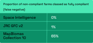
Space Intelligence incorrectly passed 0 the non-compliant farms, compared with 1% for JRC GFC v2 and 65% for MapBiomas Collection 10. These figures highlight the risk of relying on open datasets that are not calibrated for EUDR compliance.
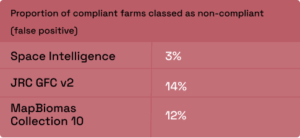
On the contrary, we only failed 3% of compliant farms, compared to MapBiomas 12% and JRC 14%. We’re continuously working to improve our maps and reduce the failing of compliant farms below 1%. That is why we have developed an Appeals Process where our expert team reviews plots that ICE CoT fails but a submitter believes should pass, and we then use expert analysis of high resolution satellite data to determine whether a plot should pass.
Conclusion
Open source nature datasets are incredible resources – and we use them regularly at Space Intelligence. But for EUDR compliance, small differences in accuracy can become major risks. You need data built to withstand scrutiny.
It is also worth noting that while none of the sampled fields contained EUDR-defined forest, Brazilian coffee farms (which may include several fields) are often legally required to maintain areas of forest. ICE CoT, which uses Space Intelligence maps to issue pass/fail badges for traders and buyers, automatically excludes these areas from assessment. Using open-source datasets instead would likely result in compliant Brazilian coffee farms being incorrectly flagged as having been deforested, further magnifying the differences shown in these results.
If you’re like to explore our maps and see ICE CoT in action, speak to us.