Scope 3 - Space Intelligence

SCOPE 3

Commodity-linked Scope 3 emissions reporting

Space Intelligence’s Scope 3 FLAG Emissions reporting built on our audit-grade commodity data supports you in generating higher accuracy data on liable emissions from your supply chain.

Most global forest datasets don’t separate soft commodities. They show tree cover loss, but not whether that loss is linked to coffee, cocoa or palm oil in your supply chain.

If you can’t isolate deforestation to your specific commodity, you risk attributing all land-use change in a region to your supply chain – overstating emissions by as much as 60%.

Space Intelligence has developed a GHG-aligned methodology built on highly accurate, audit-grade maps of coffee, cocoa and palm oil to isolate commodity-linked deforestation and present a more accurate picture of your emissions.

Report Only Commodity-linked Deforestation

Using on our audit-grade maps of coffee, cocoa, and palm oil, we track emissions at commodity, farm, and sourcing-region level.

This allows you to report only the emissions directly linked to your supply chain — not unrelated deforestation occurring elsewhere.


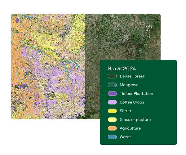
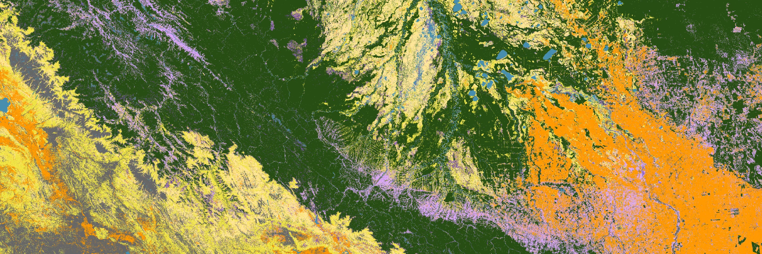
Commodity and region-specific data arrow
Our proprietary 10m resolution coffee and cocoa maps in 35+ producing countries act as the filter required by the GHG Protocol to remove unrelated deforestation noise.
Isolating coffee and cocoa arrow
Crops are often planted within, or under, natural forest to protect them from sun or weather conditions, which makes deforestation tracking via remote sensing a challenge. Our maps are specifically calibrated to detect coffee and cocoa separately from other trees.
Audit-grade accuracy arrow
We rigorously assess the uncertainty of our data, ensuring that every map meets our 90%+ accuracy threshold.

Apply Linear Deforestation Discounting

Annual deforestation data allows you to use the linear discounting approach, whereby you isolate historical deforestation to reduce the weight of historical land-use change in today’s calculations. This provides a more accurate picture of your current emissions.


Annual deforestation data arrow
Our annual deforestation data dating back to 2000 is based on our screening-grade dataset which combines the strengths of 18 open datasets.
Robust carbon estimates arrow
Carbon estimates for previous standing forest are estimated using our global carbon maps and our expert ecologist expertise.

Expertly Produced Geospatial Data and Reporting

Our approach is built on decades of carbon and geospatial scientific expertise. Receive expert-backed reporting based on audit-grade data for accurate and defensible Scope 3 FLAG estimates.


EUDR-compliant data arrow
Our data is trusted by Intercontinental Exchange for the development of ICE CoT to support EUDR compliance for major commodity buyers, traders and producers.
Calibrated approach arrow
Each project and location receives a custom approach based on our high-resolution maps and expertise.
Contact us