Back

CarbonMapper supports nature-based solution developers in maximising the carbon credits earned through projects by reliability measuring the carbon stocks in a project area. 

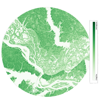
We use 20-30m spatial resolution geospatial data and our expertise in forest ecology and remote sensing to produce highly accurate maps of regional above-ground biomass.
Reduce Errors in Carbon Estimates

CarbonMapper supports nature-based solution developers in maximising the carbon credits earned through projects by reliability measuring the carbon stocks in a project area. 

We use 20-30m spatial resolution geospatial data and our expertise in forest ecology and remote sensing to produce highly accurate maps of regional above-ground biomass.

AGB Map Amazon

Monitor the Carbon Impact of Forest Degradation

CarbonMapper provides accurate carbon stock estimates given per-pixel to reveal subtle differences over time, such as forest degradation.

By measuring and comparing points-in-time we can produce change maps of total carbon density change over any given period.
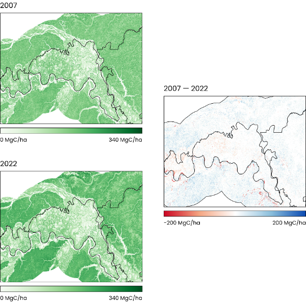
Project dev - Carbon Change Maps, Amazonas WCS (1)

How It Works

Map pointer

We gather your requirements.

We work with you to gather the data about your project, including existing field data, plots, and time periods for review.

Satellite Icon

We analyse.

Carbon stocks are calculated by fusing multiple layers of satellite and field data are fused together, including LiDAR and SAR, using peer-reviewed methods developed by our founders.

Report Check

We provide you with all the information.

You receive the data you need in the format you need it. Out-of-the-box insights are collated into a bespoke report, alongside any required data files and maps you need for further use.

Maximise your project’s impact

Space Intelligence is the trusted provider to both sides of the nature-based solutions ecosystem and is on a mission to end deforestation and achieve mass reforestation by helping to support high-quality forest carbon projects.

Our deep experience means we are a trusted partner that understands your needs.

Enquire now to explore how to maximise your project’s impact with Space Intelligence.

Contact us

Recent News

Brazil Map Completed: Announcing Brazil in Full Colour

We’re proud to announce the completion of our national land cover maps for Brazil – our largest and most ambitious mapping project to date. Spanning more than 850 million hectares, our newly released Brazil maps …

VM0047 v 1.1: What You Need To Know

Verra has recently released a minor revision to its Afforestation, Reforestation, and Revegetation (ARR) methodology, with VM0047 v 1.1 published on 14th May 2025. This update introduces several clarifications and refinements aimed at enhancing the …

Why Ecology Expertise is Key for Robust MRV

You can’t make investment decisions based on data you’re not confident in. As we explored in our recent article on how to assess the quality of nature data, creating highly accurate, audit-grade forest maps involves …

5 questions to assess nature-mapping data quality

If you’re investing or buying credits, your net-zero claims are only as strong as the data backing them. If you’re developing a project, that same data influences how many credits you can issue – and …