Space Intelligence partners with Abatable to Strengthen Scope 3 FLAG Reporting
We’re excited to announce our strategic partnership with Abatable to raise the bar on the accuracy of Scope 3 reporting.
By combining Abatable’s supply shed intelligence platform with Space Intelligence’s high-accuracy soft commodity mapping, we’re helping organisations to accurately measure and mitigate land-use emissions under Scope 3 FLAG.
Raising the Bar on Scope 3 Emissions Reporting
For most companies, Scope 3 is the largest part of their emissions footprint – and one that’s hardest to measure with high confidence.
Traceability challenges and a lack of robust crop maps have traditionally forced many companies into using Statistical Land Use Change (sLUC) methods – relying on regional averages and default emission factors per tonne of commodity, rather than isolating to the impact of specific commodities. This significantly inflates emissions estimates.
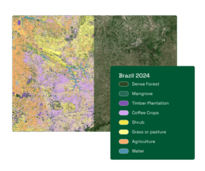
Most openly available nature datasets only show where tree cover loss has occurred. They do not tell you what caused it.
This is where Space Intelligence provides a step change in accuracy.
Using our catalogue crop maps across 35+ countries – including audit-grade coffee and cocoa maps used by ICE CoT to support EUDR compliance – we isolate jurisdictional deforestation to relevant commodities only; unlocking a robust Jurisdictional dLUC model to help you increase reporting accuracy.
Our historical deforestation dataset, dating back to 2000, also enables linear modelling to improve granularity and attribution.
This approach has been shown to reduce estimated Scope 3 emissions by over 60% by compared to default estimates, based on an analysis in Côte d’Ivoire comparing Space Intelligence’s Scope 3 Emissions Reporting Service with a default estimate using IPCC emissions factors and Global Forest Watch deforestation data.
This approach is integrated with Abatable, who bring deep expertise in value chain mitigation, leveraging its proprietary technology to map corporate supply sheds against a global database of over 13,000 carbon projects. Abatable empowers companies to take action on their Scope 3 emissions through ‘insetting’ market-based instruments, enabling them to identify and source high-integrity commodity EACs and connect directly with implementation partners developing those projects in the specific commodity sourcing regions.
A Shared Focus
At Space Intelligence, our focus is to deliver audit-grade geospatial data that makes nature-based reporting and investment more accurate and defensible.
Partnering with Abatable allows us to connect high-accuracy data with high-integrity mitigation – giving organisations the tools to act on Scope 3 emissions with confidence.
This is a step forward for transparent reporting, and stronger land-based climate action – bringing us closer to our mission of ending global deforestation.