Bruised Earth uncovered by new mapping product

The combined impact of deforestation and biodiversity loss in the tropics has been laid bare by a new mapping product from Space Intelligence.
The nature data specialist has combined datasets from multiple sources and applied expert knowledge to illustrate the impact of human destruction on tropical ecosystems.
“This map makes for very sobering viewing,” said Chief Scientist Professor Ed Mitchard.
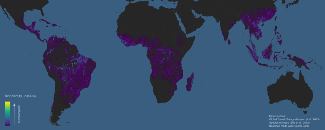
“All the areas in purple show 10km by 10km areas where forest cover has decreased significantly from 2018. We overlaid information about the richness of plant biodiversity, to show the areas where the most species have either been recently lost, or are most at risk. The turquoise spots show the most critical points, where there is rich biodiversity but over half the remaining forest has been lost in the last five years. In and around these spots biodiversity is clearly under very serious threat.”
The data show the areas most at risk are located in Vietnam, where there are highly biodiverse 10km by 10km areas with up to 61% forest loss, in Nicaragua with up to 65% forest loss, and in Papua New Guinea with up to 56% forest loss. Other countries with biodiverse patches under serious threat include Malaysia, Indonesia and Brazil.
This biodiversity risk layer forms part of a suite of layers named EarthMapper, developed by Space Intelligence to populate their ‘NBS Insights Platform’ which helps project developers and their funders make decisions about where to site Nature Based Solutions (NBS) projects. It joins Space Intelligence’s audit-grade on-demand products CarbonMapper, HabitatMapper and CanopyMapper, already used by project managers and investors globally.
EarthMapper gives a global overview of nature and its threats, using a variety of planet-wide datasets on deforestation, past and current landcover, and biodiversity risk, to help find the areas in most need of intervention. By directing resources in this targeted way, they can make the biggest impact on preventing or reversing habitat destruction.
An additional benefit is that avoided deforestation projects located in the areas of highest risk areas will earn the most carbon credits, thus creating a strong financial incentive for reversing deforestation.
EarthMapper is already being used to great effect by clients including project managers and financial institutions looking to assess their nature-related risk and impact. Beyond NBS projects, it is popular with those organisations looking to comply with new EU regulations which ensure supply chains are deforestation-free.
“Our EarthMapper product illustrates the importance of nature-based solutions to climate change as the benefits are not simply about reducing CO2 emissions by protecting the forests, they are also about protecting biodiversity and local livelihoods. If we want to reverse the serious damage that has been done to our environment, we should make data-driven decisions informed by maps like this,” Professor Mitchard added.
References :
Hansen, M.C., Potapov, P.V., Moore, R., Hancher, M., Turubanova, S.A., Tyukavina, A., Thau, D., Stehman, S.V., Goetz, S.J., Loveland, T.R., Kommareddy, A., Egorov, A., Chini, L., Justice, C.O., Townshend, J.R.G. (2013) High-Resolution Global Maps of 21st-Century Forest Cover Change. Science 342(6160), 850-853, https://doi.org/10.1126/science.1244693. https://www.science.org/doi/10.1126/science.1244693
Ellis, E.C., Antill, E.C., Kreft, H. (2012) All Is Not Loss: Plant Biodiversity in the Anthropocene. PLOS ONE 7(1), e30535, https://doi.org/10.1371/journal.pone.0030535

